Cold and wet start to Easter Bank Holiday weekend, with temperatures to drop to -2 degrees overnight
Stock image
Met Éireann has forecast a cold and wet start to the Easter Bank Holiday, with heavy showers bringing the possibility of “isolated thunderstorms.”
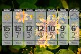
A cold and frosty start for some with a mix of sunny spells and scattered showers mainly affecting the southern half of the country at first this morning.
Later in the morning and into the afternoon more cloud will build and showers will become more widespread.
Some of the showers will be heavy and of hail with an isolated thunderstorm possible. Highest temperatures of 8 to 12 degrees in light to moderate southerly winds.
A good deal of dry weather overnight with clear spells and just isolated showers.
However, more frequent showers will develop in the south towards dawn.
American travels to Kerry to fulfil lifelong ambition of singing the 'Rose of Tralee'
A touch of frost is possible with lowest temperatures of -2 to 4 degrees in light to moderate southerly winds.
There will be a status yellow wind warning for southwest coasts from Mizen Head to Valentia to Slyne Head, with southerly winds reaching gale force 8 at times. The warning is in place from 4am on Saturday to 2pm Saturday.
However, there will be a largely dry start on Saturday with sunny spells but blustery showers will spread northwards across the country during the morning and afternoon, some turning heavy with hail.
Highest temperatures of 9 to 12 degrees in moderate to fresh southerly winds, strong at times in the southwest.
Saturday night will see a mix of clear spells and isolated showers at first. Those showers will clear to the north early in the night and it will briefly turn drier.
However, further showers or longer spells of rain will develop in the south and spread northwards overnight.
Lowest temperatures of 3 to 7 degrees in light to moderate southeasterly winds.
Easter Sunday will be quite cloudy at times with continued showers, turning heavy in some places.
Brighter and sunnier conditions will develop for a time in the afternoon. Milder with highest temperatures of 10 to 13 degrees in light to moderate southeasterly winds.
Sunday night will see further showers or longer spells of rain move across Munster and south Connacht through the night with isolated showers continuing elsewhere.
Lowest temperatures of 2 to 6 degrees in light easterly winds.
Continuing wet across the south and west into Easter Monday, with drier and brighter weather in the north and east.
Highest temperatures of 9 to 13 degrees in light to moderate easterly or variable winds.
On Monday night, showers will ease becoming more isolated early in the night.
Clear spells and mainly dry conditions for much of the night before showers increase towards morning. Lowest temperatures of 1 to 5 degrees in light easterly or variable winds.
It will become wet and dull on Tuesday as rain pushes in from the south through the afternoon with showers continuing elsewhere.
Highest temperatures of 7 to 12 degrees in moderate to fresh easterly winds.
"Remaining unsettled and becoming colder next week,” Met Éireann said.
Join the Irish Independent WhatsApp channel
Stay up to date with all the latest news